Unlocking insights and empowering decisions
Harnessing the power of interactive geospatial data in a next-generation Geo-Visualisation Platform
In the evolving world of digital technology, platforms like GeoMachine are playing an increasingly crucial role in the interpretation and visualisation of multidimensional geographical data. Offering a set of robust and adaptable tools, GeoMachine transforms the complex landscape of geo-visualisation into a more user-friendly and accessible framework. This is essential in unifying diverse domains such as the air, sea, and land sectors, contributing to an interdisciplinary approach to data interpretation.
GeoMachine stands out due to its highly customisable components. They act as versatile building blocks that can be tailored and deployed to suit various needs. Whether you're looking for a comprehensive WebGIS interaction platform or a bespoke configuration to tackle a specific task, GeoMachine's adaptability can cater to these needs.
This level of customisation fosters a more efficient approach to data interpretation, bridging the gap between complex geographical information and its practical implementation.
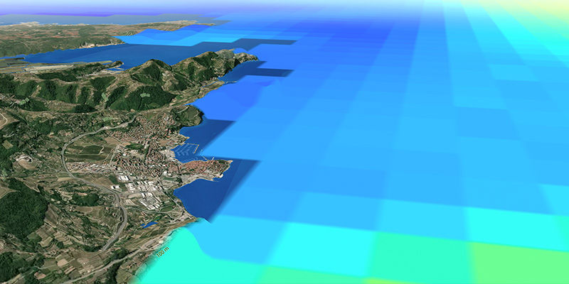
In the broad spectrum of environmental sectors, GeoMachine is already proving its value. Deployed in multiple instances, it caters to a wide variety of use cases. From the creation of simple maps and plots to the development of fully interactive real-time digital twins connected to sensors, IoT, data archive centres, and even AI systems, GeoMachine is revolutionising the way data is interpreted and presented. This isn't merely about visualising data; it's about bringing data to life in the most functional and insightful way possible.
Transforming Geo-Visualisation in a Data-Driven World
What makes GeoMachine different?
In a realm where the comprehension and analysis of multidimensional geographical data becomes progressively more critical, platforms like GeoMachine break new ground. Unlike many other WebGIS platforms, GeoMachine simplifies the intricacies of geo-visualisation and makes it universally accessible. This transformative capability spans across multiple domains—air, sea, and land—providing an inclusive, interdisciplinary interface for data interpretation.
One of the defining characteristics of GeoMachine is its high degree of customisability, setting it apart from many of its counterparts. Its components act as flexible building blocks that can be adjusted to serve a variety of purposes. This unique ability to cater to a wide array of needs - from comprehensive WebGIS interaction platforms to task-specific bespoke configurations - gives GeoMachine a competitive edge in the market.
Already deployed in various environmental sectors, GeoMachine has demonstrated its versatility by satisfying an extensive range of use cases. It's not limited to simple maps and plots. Instead, it encompasses more advanced applications, such as the creation of fully interactive real-time digital twins.
GeoMachine's seamless integration with sensors, IoT, data archive centres, and AI systems further extends its capabilities, making it a truly forward-thinking platform.
A testament to its innovation is how GeoMachine transforms data visualisation into an immersive experience. It doesn't just display data; it breathes life into it, enhancing the understanding and interpretation of complex information. It's this unprecedented functionality that allows GeoMachine to bridge the gap between data and its practical implementation.
GeoMachine's bespoke adaptability, comprehensive integration, and transformative visualisation capabilities set it apart from other WebGIS platforms. It isn't merely a platform; it's a key tool in unlocking the full potential of complex, multidimensional data. By fostering an accessible, versatile, and insightful approach to geo-visualisation, GeoMachine is redefining how we navigate and comprehend our increasingly data-driven world.
Unlock Innovative Data Visualisation with GeoMachine: Your Control Centre
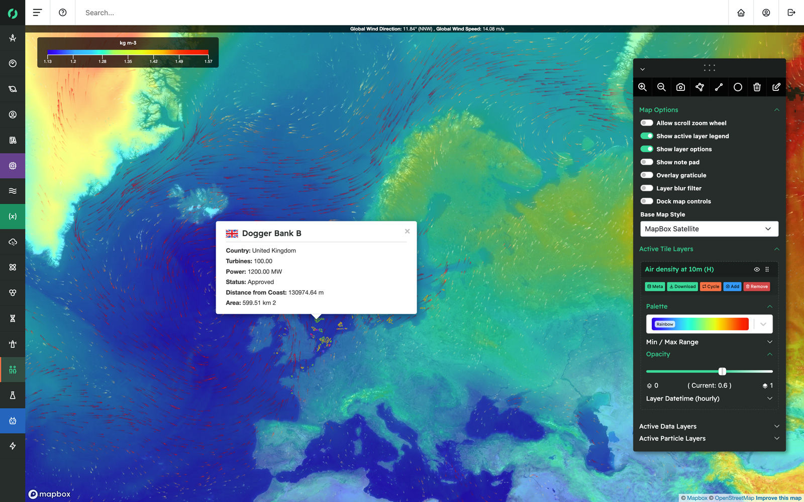
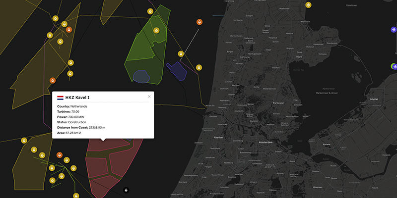
With GeoMachine, you gain the ability to visualise virtually any type of data in a unique, configurable way that places you at the helm of design. Through intuitive side panels, features can be seamlessly displayed on maps, allowing you to navigate across the earth's expanse with just a simple click. GeoMachine's adaptive interface ensures that you remain in control, empowering you to explore and comprehend the complex world of data with ease and precision.
Customise Your Canvas to Complement Your Data with GeoMachine
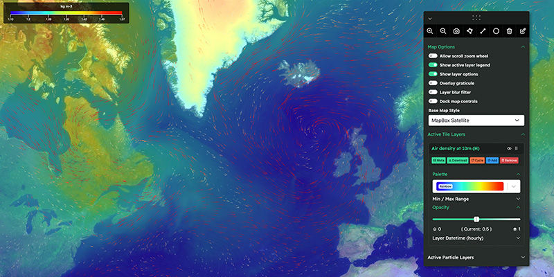
GeoMachine offers a plethora of map types and options, enabling you to control the minutiae of your visualisation, from colour schemes to the opacity of individual elements. Our sophisticated catalogue engine empowers map owners to customise the data display and establish default filters for their data sets. In essence, GeoMachine ensures that your canvas is not just a display, but a tailor-made interpretation of your unique data.

Custom Dashboards, Annotations, and Code Exports: Enhanced Collaboration with GeoMachine
We're dedicated to making dashboards a central feature of GeoMachine, enabling users to amalgamate diverse data sources into a highly customisable perspective. Beyond this, advanced integrations are available, including the ability to export code snippets to Jupyter notebooks, broadening the possibilities of collaboration and data interaction within the platform.
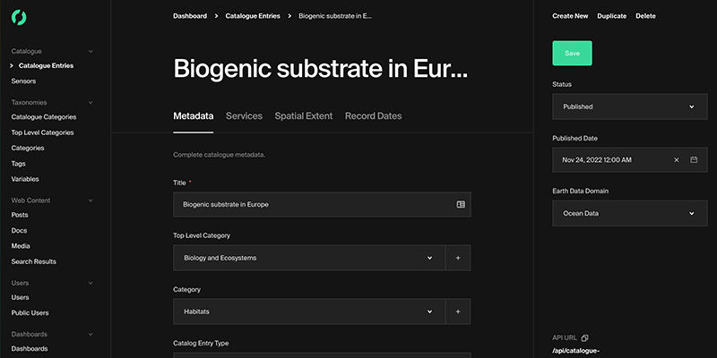
Unifying Resources with GeoMachine's Robust Catalogue System
For application administrators, GeoMachine offers an intuitive catalogue system, enabling the grouping and displaying of data in numerous ways. Designed with extensibility in mind, our catalogue system adapts to technological advancements, making room for integration of emerging technologies. GeoMachine’s catalogue system isn’t just a tool—it's a strategy for keeping your data interaction and visualisation modern and efficient.
GeoMachine: Engineered for Tomorrow's Technologies Today
From Artificial Intelligence to Virtual and Augmented Reality, GeoMachine is being primed to embrace a spectrum of groundbreaking features in the future. We've been exploring these cutting-edge technologies and their potential implementations will surely astound you. The demos we've been working on are just the tip of the iceberg. Stay connected! You won't want to miss the exciting innovations that GeoMachine is set to introduce.
Seamless Access to Large-Scale Data Sets with GeoMachine
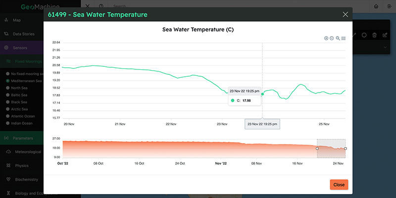
Scouring through vast quantities of information compiled by international institutions and government entities can be daunting. That's where GeoMachine steps in, crafting tools designed to streamline this process. With our platform, you can easily delve into decades' worth of near-real-time data, transforming a potentially overwhelming task into a manageable and efficient endeavour. GeoMachine is all about making big data user-friendly and accessible.
A constantly evolving toolset
Roadmap
GeoMachine is not just a platform—it's an ongoing journey towards an evolving technological horizon. Its very essence lies in its adaptability and readiness to incorporate new technological evolutions. Our team understands that the digital landscape is not static; it evolves and progresses at an incredible pace. Hence, GeoMachine is designed to do the same. We are continuously refining, improving, and expanding our platform, staying in sync with the latest innovations, trends, and advancements in technology.
At the core of our strategy is a comprehensive development roadmap. This roadmap charts our course through the ever-changing tech landscape, ensuring that GeoMachine always stays at the forefront of industry advancements.
From AI to VR and AR, no stone is left unturned in our pursuit of the next game-changing feature or function. We believe in a future where geo-visualisation is seamlessly integrated with the most cutting-edge technologies, and GeoMachine is our vehicle to realise that future. Rest assured that as a user of GeoMachine, you are not just using a product, but being part of a continual technological journey.
Q3 2023
Launching independent machine for the Horizon 2020 project EcoScope
Connecting with Horizon 2020 project Iliad’s digital twins
Q4 2023
Jupyter notebook integration
Exportable code snippets for data analysis
Improved mobile support
Q1 2024
Support for any ERDDAP resource
Expansion of machine types and Earth Science sectors
Integration of GeoMachine in the Iliad Digital Twins Marketplace
Q2 2024